Compiled by Shirley Harris. Additions, corrections and suggestions for pictures are welcome, to webhelp@todwalkers.org.uk
Back Stone Hill – on the northern edge of Whirlow Common. Backstone is a dialect word for a baking stone, commonly used to bake haverbread (a type of oat pancake) which could have been quarried at this site
Beck – stream
Birks – birches eg Brown Birks above Cornholme
Booth – name given to a wooden hut lived in by a cow herd or boothsman. Some high ground in this area was once used for cow pasture in large vaccaries or cattle ranches.
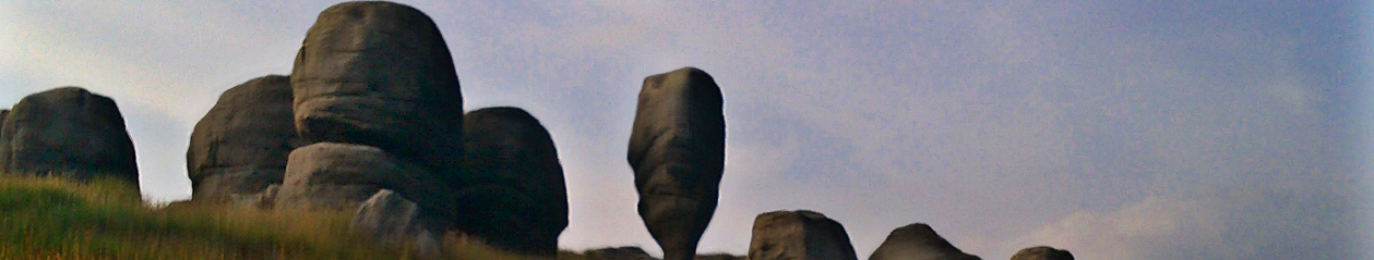
Bride Stones – strangely shaped, wind sculpted rocks on the moors north west of Todmorden (featured in our website header). Named after the deity Brigid (known in Scotland as Bride), worshipped in the Celtic kingdom of Brigantia, which once covered northern England. This name is used for other prominent stones in North Yorkshire.They were associated with marriage and fertility rituals
Brig – bridge
By – Viking for a farmstead or village
Cairn – pile of stones (of varying height and size) marking either the start or the ongoing route of a footpath.
Causey (causeway) – narrow path surfaced in local stone flags to enable packhorses to negotiate rough and/or boggy ground. There are good examples around Lumbutts.
Calder (River) – violent or cold river, can also mean oak.
Carr – probably derived from the Old Norse word kjarr, meaning swamp or wet hollow e.g. Carr and Craggs Moor above Cornholme.
Cathole – an area of Hudson Clough, which runs down to Lydgate from Hudson Moor. There is a Cathole stone on the side of the clough, roughly inscribed with a cross and the words “Jesus Lord God of the Mountains” in old Latin. This may have been used by the navvies from the shanty town at Knotts, practising their Catholic religion. Hudson Clough was once the site of the Catholes dam, constructed to provide water power to Jumps, an early cotton mill. Is the dam still there?
Clapper (Bridge) large piece or pieces of stone used to form a footbridge across a stream e.g. the 15th century bridge at Hebble Hole in Colden Clough. (Hebble is a dialect word for a narrow bridge or its rail).
Clunter – to run together in clots or lumps, to put together clumsily or a big lump. Old Yorkshire expression for to stamp feet or make a rude noise with feet when walking.
Corpse Road – old route used to carry coffins from settlements without churches to an adjacent burial ground. An example is Withens Gate which linked Cragg Vale with the chapels at Mankinholes and Lumbutts. The Te Deum Stone, on this route (inscribed with a cross and the letters I D) is said to have been a resting point for coffin bearers
Croft – a farm or area of fenced land. Can also refer to land used for the outdoor bleaching of cloth. Examples include Croft Gate, Farm and Carr at Mankinholes.
Cornholme – corn field. The name of a bobbin mill built by the Wilson brothers in the early 19th century which gave its name to the adjacent settlement.
Cots – buildings e.g. Kebcote near Blackshaw Head.
Clough –steep valley e.g. Pudsey, Wittonstall and Gorpley
Day holes or drift mines – small, shallow mine workings in the ground above coal seams. Examples can be found on Todmorden Moor.
Delph – quarry, examples in Jumble Hole
Den (dene) – Viking for a valley e.g. Walsden, Ramsden and Colden
Der – water as in Calder
Eagle Crag – also known as the Witches Horse Block is visible on the skyline near The Staff of Life Inn on Burnley Road near Cornholme. It was previously known as Bill Knipe, a name possibly derived from the Norse for a projecting rock.
Elmet – the name given to a kingdom which once stretched across the whole of modern West Yorkshire and was established after the Romans left Britain. The Yorkshire poet Ted Hughes named a volume of his poetry The Remains of Elmet. This is illustrated with photographs of local views by the notable landscape photographer Fay Godwin. The name still survives as Sherbern-in-Elmet in North Yorkshire.
Enclosure Acts – these provided the legal framework for landowners to enclose common land for agricultural purposes. Enclosures are characterised by large, regular shaped fields, straight tracks and long drainage ditches.
The enclosure of land once held and farmed in common had serious detrimental consequences for the already precarious livelihoods of working country people. In this area most members of rural households were obliged to work in the mills in the valley bottoms though many remote farms were abandoned in the late nineteenth and early twentieth centuries.
The Cotton Famine of the 1860s when the American Civil War limited the export of raw cotton and resulted in the subsequent closure of many mills. This lead to further enclosures some with substantial stone boundary walls, the construction of which provided work for unemployed mill workers. A similar initiative involved the Fieldens of Todmorden paying their workers to build London Road and Withens New Road.
Field – open tract of land e.g. Inchfield and Langfield
Fell – hillside
Felt – Norman for field eg Stansfelt
Forest – an area of land not necessarily wooded but protected or reserved for hunting deer or boar.
Gate – Viking for roadway or street e.g. Limers’ Gate
Gill – small ravine
Ginnel – narrow alleyway or passage
Goit – water channel (or tail race) leading from a water powered mill e.g. Hebden Bridge town centre.
Harbour – the word is thought to have come from an Old High German word heriberger referring to an open enclosure where an army would camp on a march. It can also mean shelter or refuge. An example is Windy Harbour
Ham – Anglo-Saxon for a settlement or community
Haugh – enclosure
Hebble – a dialect word for a narrow bridge or its rail.
Hebden – rose-hip valley
Hey – Anglo-Saxon for an enclosure
Hol, how – hill
Hole – hollow e.g. Hole Bottom
Holme – field, meadow, clearing
Hurst – copse or woodland e.g. Ashenhurst and Kilnhurst.
Ing – Anglo-Saxon for a settlement e.g. Ingfield and Ing Bottom in Cornholme and Pudding Lane at Shore.
Intake – an area of land reclaimed from the moorland edge and improved for grazing.
Jubb or Judd – waste stone unsuitable for building construction or a wall constructed to retain quarry waste.
Keb – a dialect word for an old ewe as at Kebcote and Kebs Road, Blackshaw Head.
Laithe – a Yorkshire dialect word for a barn.
Laithe House – a type of farmhouse where the laithe or barn was attached to the house. This form of construction had cattle stalls at one end and living accommodation with hand looms at the other. They were usually built in upland areas where due to poor quality land, farmers needed a second source of income from weaving in order to survive. Although some date from the 17th century they more commonly date from the late 18th century.
Ley (Lee and leah) – Anglo-Saxon for pasture, field or glade/clearing in woodland e.g. New Ley, Hartley, Harley and Ferney Lee.
Lonk – an old name for a hardy sheep bred in the south Pennines. The name is a corruption of ‘lanky’. It has a black face and long legs.
Lumbutts – the pool (lumm) abutting the strip of land
Lund – small wood
Mankinholes – Scandinavian for Mancan’s hollow. Mancan is an Irish name, which may have come from an older Viking colony in Ireland.
Moss – peat bog, swamp
Mythum – Anglo-Saxon word for a place where two rivers meet e.g. the Calder and the Cragg Brook at Mytholmroyd (the full meaning of the name being – land cleared for cultivation where two rivers meet).
Naze – a headland or promontory e.g. Knotts near Cornholme and Whitaker near Portsmouth.
New Bricks – name given to land reclaimed from the moors and improved for grazing.
Old Woman – the most prominent of the crags in the woods above Portsmouth. The name is thought to be related to the mother goddess of the land and weather known as the Cailleach in gaelic. Christians commonly referred to pagan beliefs as Old Lad. Old Wife or Old Woman.
Orchan Rocks – a striking rocky outcrop on the skyline between Todmorden and Cornholme. The name may be a corruption of rocking stone or they may have been thought to look like an organ. Their name was spelt as ‘orkynd in the 15th century.
Owlers – alders
Packhorse – horse or pony used for carrying goods on their backs in side bags or panniers over rough ground prior to the construction of turnpike roads in the late eighteenth century. They were used to transport raw wool, cotton or spun yarn to handloom weavers in farms and cottages and to take woven cloth to market.
Packhorse Bridge – narrow, low sided stone arched bridge to allow laden horses with panniers to cross rivers and streams. Examples include Hudson Bridge east of Hartley Royd. Any other examples ?
Pike – hill with a pointed summit. Also the name given to the monument at Stoodley.
Portsmouth – village adjacent to Cornholme, said to have been named by the son of the first landlord of the Roebuck Inn, who was a mariner.
Rake – old Viking word meaning steep road leading onto moor land e.g. Old Rake, Dobroyd.
Reaps – a name given to land reclaimed from the moors for grazing.
Riding – land rid of rocks (in terms of the old Ridings of Yorkshire it means a third).
Rigg – hill top
Royd (rode) – Anglo-Saxon word for a settlement or land cleared for cultivation, dates from the fourteenth century. Examples include Hartley Royd and Dobroyd.
Shanty – rough temporary dwellings in small settlements built by navvies building canals, railways and working in stone quarries. There was once a shanty town below the stone quarries in Knotts wood near Cornholme
Shaw – copse or woodland e.g. Blackshaw (Head)
Sheep Creep – purposely constructed gap in the base of a dry stone wall to allow sheep to pass from field to field (too small for cattle or horses). Also known as sheep runs, cripple holes, hogg holes or sheep smouts.
Shore – steep cliff
Slack – hollow
Stang pole gateway – from stang or stanger the Norse word for pole. An early form of farm gateway, which involved slotting wooden poles between two stone gateposts, one with holes in the side and the other with diagonal grooves.
Stansfield – stony field
Stones – a hamlet on the south eastern edge of Todmorden Moor, named after the three standing stones in its vicinity.
Stoop – originally referred to a stone marking the route of a track but is now used to refer to any vertical stone as well as an abbreviation of gate-stoop.
Stubbing – Anglo-Saxon word for land cleared for agriculture e.g. Stubbing Wharf
Tenters – wooden frames (sometimes with stone posts) onto which newly woven wool or linen cloth was stretched in order to dry flat and to bleach in the sun. Gives rise to the phrase “to be on tenterhooks”.
Todmorden – a number of definitions have been put forward for this name. These include the valley of Totta’s marsh, valley of Totmar (Totmar being a hill marsh or hill lake), Totta’s boundary or valley and the moorland/hill/valley/marshy home of the tots (foxes).
Alternatively a “tod” is also a term once used for a 28lb weight of wool. Tods were weighed at the October, Michaelmas fair at Mankinholes when farmers and shopkeepers disposed of their fleeces of wool. The fair moved to the confluence of the three valleys when a church was built there.
When Bismark the German chancellor visited Manchester in the 19th Century he is reputed to have looked in a local railway guide for a destination for a break and read Todmorden as “murder”, remarking that “it matches its name”.
Ton – Anglo-Saxon for farmstead
Tonstall – farmstead e.g. Heptonstall and Wittanstall. Also indicates the use of land as a vaccary or cattle ranch
Toot – Anglo-Saxon for tower or observation post.
Turbary – an old right of country people to take peat for their own personal use from common land on the high moors.
Turnpike – metalled roads constructed by private companies or trusts from the mid eighteenth century onwards, usually in the valley bottoms to link major urban settlements. Payment or tolls were charged for their use at toll gates or toll bars.
Walsden – the valley of the walhs (the English name for foreigner).
Wittonstall – “Withig” (willow) farmstead
Worth – enclosure